A new study by University of the Philippines meteorologists sheds light on how tropical cyclones behave near Philippine coasts. It reveals urgent needs for improved storm preparedness. The research covers 45 years of data. It analyzes 372 landfalling tropical cyclones from 1979 to 2024. Drs. Bernard Alan Racoma and Gerry Bagtasa led the study. They are from the UP Diliman College of Science’s Institute of Environmental Science and Meteorology (UPD-CS IESM). Their findings highlight key patterns in storm movement and intensity. These insights can help save lives.
Storms hitting northern Philippines tend to be stronger. But they move slower. Southern storms are faster. They also accelerate more quickly. This difference affects the type of danger each region faces. Dr. Racoma explained this clearly. “Storms that hit the northern part of the country tend to be stronger but slower moving,” he said. “Southern storms tend to be faster and accelerate more rapidly.” He added, “This has implications on the kinds of hazards these storms may bring.”
Faster storms in Visayas and Mindanao give people less time to act. Communities may not have enough time to evacuate. They might not secure their homes or gather supplies. In Luzon, slower storms bring different risks. Their long duration increases flooding. Landslides become more likely. Even if a storm weakens slightly, its prolonged presence can be deadly.
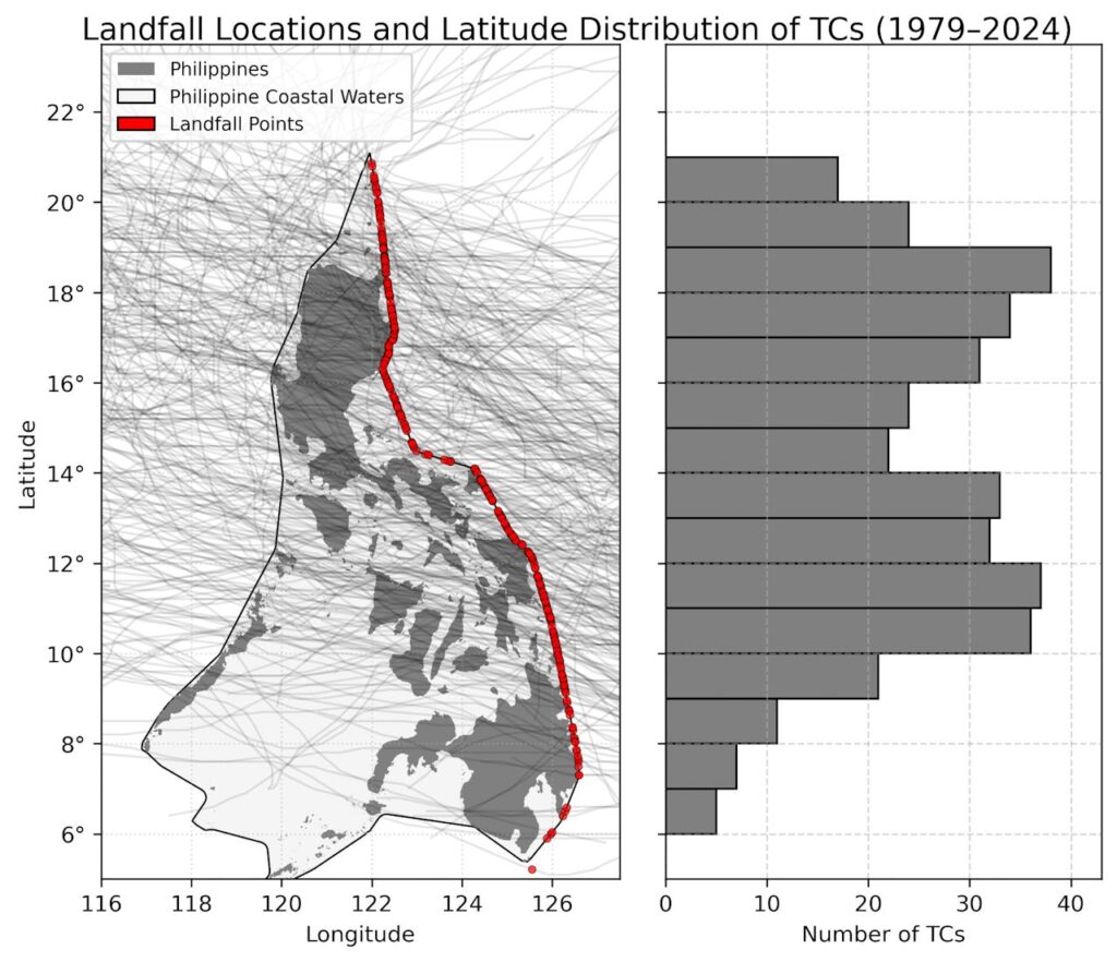
The study found another key detail. Tropical cyclones spend only a short time near the coast. On average, just 21 hours pass while a storm moves along the shoreline. After that, it moves inland or away. This brief window limits how much time officials have to respond.
Why is coastal exposure so short? Dr. Racoma offered two reasons. “In terms of geometry, medyo balingkinitan ang Pilipinas,” he said. The country is longer from north to south than east to west. Since most storms come from the east, they cross the narrow width quickly.
The second reason is about energy. “TCs draw their energy from the sea,” Dr. Racoma explained. “They typically don’t like staying over land.” Once a storm hits land, it starts to weaken. It loses its fuel — the warm ocean waters.
Understanding storm timing and intensity is crucial. The researchers stress this point. They say it is key to reducing disaster risk. Everyone should take storms seriously. Even weak systems can become dangerous fast. “Rapid intensification occurs very fast — typically within 24 hours,” Dr. Racoma warned. “We don’t yet fully understand it.”
He also reminded the public: “We should avoid waiting for a storm to intensify before preparing.” Half of all tropical cyclones that form or enter the Philippine Area of Responsibility (PAR) make landfall. Many undergo rapid intensification inside PAR.
The study was published in Tropical Cyclone Research and Review. This journal focuses on storm monitoring, forecasting, and disaster risk reduction. Support came from the UPD Office of the Vice Chancellor for Research and Development. The Department of Science and Technology – Philippine Council for Industry, Energy, and Emerging Technology Research and Development also funded the work.
This research adds to climate science in vulnerable regions. The Philippines is one of the most cyclone-prone countries in the world. Better data means better warnings. Better warnings save lives. Preparedness must start early. Storms don’t wait. Neither should we.
For inquiries you can contact UPD-CS Science Communications:
📧 media@science.upd.edu.ph
📞 (+632)8981-8500 loc. 3805
🌐 science.upd.edu.ph