

Satellite data tracked a large volcanic gas plume following the eruption of Kanlaon Volcano.
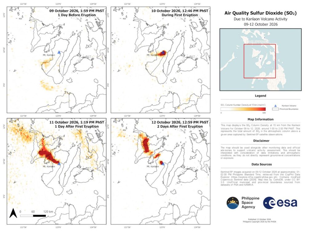
The Philippine Space Agency released a map in Oct. 14, 2026. The map shows sulfur dioxide column density within a height of 15 kilometers above the volcano. The observations cover Oct. 09 to Oct. 12, 2026.
Kanlaon Volcano erupted in Oct. 10, 2026. High gas concentrations appeared near the volcano right after the explosion.
The plume moved northwest on Oct. 11 and Oct. 12. The moving gas cloud may affect air quality in nearby areas. Provinces in the plume path include Guimaras, Iloilo, Capiz, and Aklan.
Sulfur dioxide is a common volcanic gas. Scientists use the gas to track volcanic plumes. Volcanoes release sulfur dioxide during explosive events. The gas normally exists at very low levels in clean air.
The European Space Agency operates the Sentinel-5P satellite. PhilSA gathered atmospheric data from this satellite. The satellite uses an optical imaging spectrometer. The sensor reads the spectral fingerprints of atmospheric gases.
Space technology allows experts to monitor large areas quickly. PhilSA analyzed satellite imagery to help government agencies track the ongoing situation.
Satellite readings do not show exact gas levels on the ground. Authorities use satellite maps alongside ground tools to measure air quality and monitor volcanic activity.
The Philippine Space Agency is the central space agency of the nation. The government established PhilSA in August 2019 under Republic Act No. 11363. The law is also known as the Philippine Space Act.
PhilSA plans, develops, and promotes the national space program. Its work follows the goals of the Philippine Space Policy.
The agency operates under the Office of the President of the Philippines. It aligns space programs with broader national priorities.
The public can view the high-resolution sulfur dioxide map online. PhilSA shares additional updates through its social media channels.